Oxford Hook Echo 06.03.2008 and EF0 Tornado


EF0 - No Deaths, No Injuries. A well developed mesocyclone and a well defined hook. So why was the tornado an EF0?
The sounding taken by NWS Wilmington for 00z 06.04.2008 (8PM EDT 06.03.2008) indicates a low level inversion. That means the
surface air was cooler than air a bit higher, so... surface air was more dense and therefore stable.
Forecasting Lesson: All the elements must come together for a "big one".

Enhanced Fujita Scale - EF0
Path Length - less than a mile???
Average Speed - slow???
Touch Down about 9:00 PM EDT

Oxford, Ohio 06.03.2008
A classic hook echo in a supercell moving to the southeast imbedded in NW flow aloft. Do you think there is a problem with where
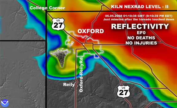
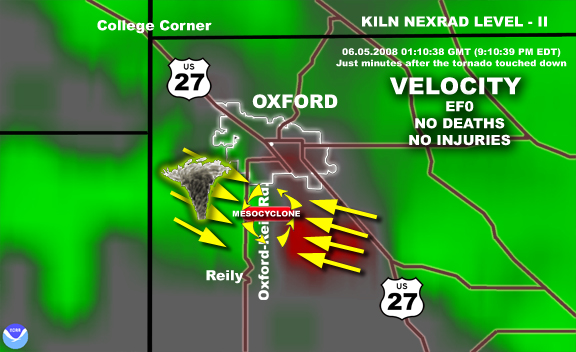
I placed the tornado?
NWS meteorologists estimated touchdown between 9PM and 9:10PM EDT. These NEXRAD images are from 9:10:38 PM EDT,
probably after touchdown. Because the storm continued to move to the SE the tornado would be WEST of where you would expect it
to be relative to the mesocyclone. Another possibility is that the tilt of the storm means the mesocyclone is east of the surface position
of the tornado. Remember you are looking at the storm about 2,100 ft. above ground level (ignoring earth curvature and refraction
of the radar beam by the atmosphere), so a tilting storm means the mesocyclone will not be above where the tornado touches down.
CLICK HERE to go the images at the NWS website

BACK TO TORNADO INDEX

BACK TO STEVE HORSTMEYER'S HOME PAGE