July 2, 1997
F3 No Fatalities
Location: Southern Clermont County
25 nm (28.75 statute miles) ESE of Cincinnati
Just WSW of Felicity, OH
Radar images courtesy of 12WKRC TV, Cincinnati, OH and the Doppler 12 Weather Center


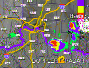
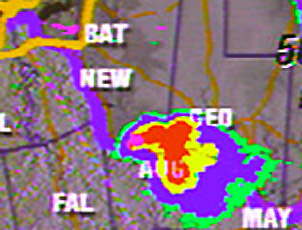
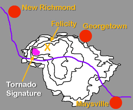
Radar Images from Doppler 12 Radar
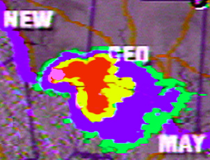
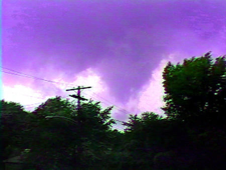
Video Frame over Ft. Mitchell, KY Key/Contour map Range-Height Indicator (vertical scan)
RANGE-HEIGHT INDICATOR WITH TORNADO ON THE GROUND
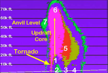
Storm is moving to the right, tornado at the rear.
1.Weak Echo Region - location of the warm moist inflow and updraft
2. Light or No Rain area ahead of tornado
3.Hail at surface - there was much hail damage with this storm
4.Heavy rain at surface - it is displayed as blue (2nd level)
due to attenuation of the radar beam
5.Hail curtain aloft
6.Overshooting top - intense updraft pierces the tropopause
forcing the storm top into the stratosphere
7.Indicator of anvil and tropopause - The anvil would be
off to the right blown ahead of storm by upper winds
IDEALIZED AIR FLOW THROUGH THIS SUPERCELL

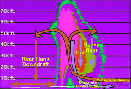
1.Warm, moist air fows into the thunderstorm and is lifted by the updraft and by the cool outflow
2. As some rain evaporates, air in the front portion of the storm is cooled and becomes more dense the increased density along with billions of rain drops pushing air ahead of them leads to the downdraft, the cool outflow we have all experienced.
3.The inflow splits, towards the front as the updraft becomes more horizontal the raindrops and hailstones are no longer held aloft by strong upward motion. Because hail is heavier it falls out closest to the updraft, raindrops are carried farther and fall farther towards the front of the storm.
4.The portion of the updraft that exits the rear of the storm, sinks as the rear flank downdraft. This leads to clearing in the rear of the storm. This is why tornado photographs often show a dark funnel against a serene, bright sky.

This supercell thunderstorm was born over Ripley, Co. Indiana and quickly became severe. An excellent wind shear environment quickly started the thunderstorm rotating.

****CLICK HERE FOR A 10P PAGE LESSON ON TORNADO FORMATION****

Buy the time the video frame above was captured over Ft. Mitchell, KY the funnel had formed but had not touched down. As the storm moved almost due east it reached southern Clermont county and the funnel touched down just a few miles WSW of Felicity, OH.

DO ALL TORNADOES FORM IN THE SOUTHWEST PART OF SUPERCELL THUNDERSTORMS?
NO!
The tornado forms in the rear of the storm. Because 90% to 95% of supercells move from SW to NE almost all tornadoes are found in the SW part of the storm. The Felicity Tornado of July 2, 1997 formed in the rear part of the storm like tornadoes do in all supercells, because the supercell was moving to the E the rear was in the W.

Some tornadoes form along gust fronts and are called gust-front tornadoes or "gustnadoes" by some. Research is ongoing and many ideas may change in the near future concerning "gustnadoes". At the present meteorologists feel that all long-lived and powerful tornadoes are spawned by supercell thunderstorms, most of the short-lived and weaker tornadoes are spawned in other ways, like lifting by a gust front (click below for more on this.) While some of the weak tornadoes are from supercells the long-lived devestating tornadoes are the product of the supercell mesocyclone.

For more on gust-front tornadoes and supercell tornadoes ****CLICK HERE****

BACK TO TORNADO INDEX

BACK TO STEVE HORSTMEYER'S HOME PAGE